Recreation site (day use only)
Region
Klondike
Serviced
to
Gate Open
Gate open year-round
Warning
Though it is a manufactured staircase you are still in the wilderness. Carry bear spray on your walk to the rapids.
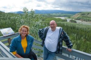
Site description
- Good place to stretch your legs while driving the North Klondike Highway.
- Features a viewing platform and a 1.4km (return) trail with interpretive panels.
- The Northern Tutchone name Tthi-chò Nädezhé means “rocks (standing up) in the water.” The 4 islands split the river into 5 channels, hence the English name.
- In the 1900s, explosives were used to widen this channel.
Location
Highway
Klondike Highway
Highway kilometre
380.0
Secondary road kilometre
0.0
GPS coordinates
62.27345°N 136.34254°W
Map download
Lieu de loisirs de Five Finger Rapids
(897.13 KB)
Download Map
Services available
Outhouse unisex
Bear-proof garbage bins
Picnic tables
Hiking trails
At least 1 wheelchair accessible outhouse
Viewing structures or signage about local cultural and natural history